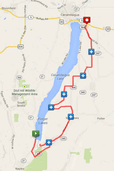
| Leg 1 |
5.34 miles
(5.34 total)
Port-A-Pottie
|
"Sunnyside" - Start to Sunnyside Aid Station
Topography: Gently Rolling Roads
- The Start is at the Boat Launch just south of Woodville. The buses will drop you in the large parking lot. There should be two portable toilets at the north end of the lot. There will be box for any bags you want to leave with the bus for transport to the finish.
- Follow directions of race officials at the start.
- Once headed south on Rte. 21, at about 0.7 miles you will pass the 50 Mile Red Garage Aid Station.
- Another mile down Rte. 21, turn left (E) on Parish Rd.
- Continue 0.8 miles on Parish Rd to T intersection with Rte 245.
- Turn left onto Rte 245. Continue on 245 for 2.2 miles.
- Turn left on Sunnyside Rd. The Aid Station is 0.5 miles ahead at the intersection of Sunnyside and West Avenue.
Handlers
- Do NOT stop on the shoulder of Rte. 21 or Rte 245 to service your runner. There's too much traffic and too little shoulder.
- Handle your runner on Parish or on Sunnyside.
- There is a small parking lot on Sunnyside just before the intersection with West Avenue.
|
| Leg 2 |
2.90 miles
(8.24 total)
Port-A-Pottie
|
"Out & Back" - Sunnyside Road
Topography: Rolling Roads
- Continue on Sunnyside Road.
- At about 0.5 miles take the left fork to stay on Sunnyside Road and close to the level of the lake.
- At 1.45 miles, a marshal will record your arrival with a photo.
- Turn around and return to the Sunnyside Aid Station.
- There will be a porta-pottie at the Aid Station.
Handlers
- Remain near the Sunnyside Aid Station and wait for your runner to return from the out & back.
|
| Leg 3 |
4.33 miles
(12.57 total)
Drop Bags
Restrooms
|
"West Avenue to Middlesex" - Sunnyside & West to Church in Middlesex
Topography: Rolling Roads
- Bear to the left out of the Aid Station onto West Avenue.
- Enjoy the gently rolling road which gently climbs to Middlesex.
- As you approach the intersection with Rte. 364 in the town of Middlesex, the Aid Station is at the Church Youth Center on the left.
- Rest rooms are available in the Church Youth Center.
Handlers
- Park on the right where signs direct you.
Cut-off time for 50 Km is 1:40PM |
| Leg 4 |
3.96 miles
(16.53 total)
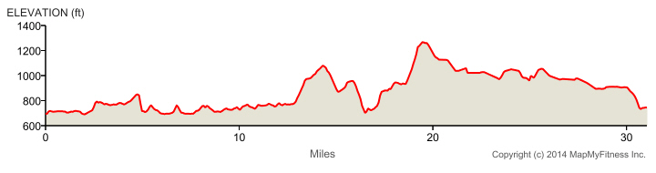
Cat. 5 Climb
1.38 mi, 3.2%
avg. grade
Port-A-Pottie
|
"South Vine Valley" - Middlesex to Vine Valley
Topography: Big Up, Big Down
- In the town of Middlesex, continue NE out of town onto Rte. 364.
- There's a pretty good climb to the intersection with S Vine Valley Road.
- Take S Vine Valley Road to the small community of Vine Valley.
- The road has a big down, then rolling hills and then drops steeply to intersect S Lake Road.
- At the T intersection, turn RIGHT (N) onto S Lake Road.
- Go north one short block and turn left (toward the lake) at the Community Center.
- The Vine Valley Aid Station will be on your left in the parking lot of the general store.
Handlers
- Do NOT park in the Community Center parking lot
- Drive down to the General Store just before the Beach Park.
- Do NOT block access to the boat launch at the end of the road.
|
| Leg 5 |
2.72 miles
(19.25 total)
Cat. 4 Climb
2.66 mi, 3.1%
avg. grade
Drop Bags
|
"Bare Hill Climb" - Vine Valley to Top of Bare Hill Climb
Topography: Long Climb Followed by Steep Climb
- From the Aid Station, run back up to the intersection and turn left on N Vine Valley Rd.
- Immediately after a steeply-climbing hairpin turn, continue straight on N Vine Valley Rd away from the lake.
- The climb on N Vine Valley Road is a moderate stair casing climb.
- Walk the steeper bits & run the easier sections.
- After climbing about 1.5 miles N Vine Valley dips and Bare Hill Rd intersects on the left.
- Turn left (N) on Bare Hill Rd.
- The 0.6 mi climb is steep but significantly easier than Bopple Hill.
- The Aid Station is at the intersection with Van Epps Road.
Handlers
- Parking is limited at this aid station.
- Do NOT park on Bare Hill Rd.
- Turn left on Van Epps Road and park on the right side of Van Epps Road.
|
| Leg 6 |
4.48 miles
(23.73 total)
Port-A-Pottie
|
"Twitchell-Green" - Bare Hill to Arnold Road
Topography: Short Up and Longer Gradual Down; Short Up Then Flat, Rolling
- Continue N on Bare Hill Road.
- At 1.0 miles, turn right (E) on Town Line Road.
- At 2.0 miles, turn Left (North) on Twitchell.
- At 3 miles, Twitchell curves to the Right (East).
- At Rte. 364 intersection, STOP and LOOK BOTH WAYS before continuing straight across 364.
- The road name changes to Green.
- Green dips and then climbs to intersect with Arnold Road.
- The Aid Station is at the intersection.
Handlers
- Park on the right before or after the aid station.
|
| Leg 7 |
3.75 miles
(27.48 total) |
"Middle Road" - Arnold to Kipp Road
Topography: Gently Rolling, Trending Downward
- Turn Left (North) on Arnold to CR 1 at 1.2 miles.
- Zag Right on CR 1 and then an immediate Left onto Conklin.
- The road dips and then gently climbs to intersect Middle Road.
- Turn Left (North) and head for home.
- The 11th and final aid station is at the intersection with Kipp Road at 3.74 miles.
Handlers
- Do NOT stop on the shoulder of busy Middle Rd to service your runner. There's too much traffic and too little shoulder.
- Turn off onto an intersecting side road to park. Then walk back to service your runner.
- At the Aid Station, turn onto Kipp Road and park on the right.
- Do not park on Middle Road.
|
| Leg 8 |
3.57 miles
(31.05 total) |
"Homestretch" - Kipp Road to Finish
Topography: Mostly Flat Then Steep Downhill with final Short Climb to Finish
- The route continues North on Middle Road to T intersection with CR 18.
- Turn Left onto CR 18. The traffic may be heavy for the next mile to Lincoln Hill Road.
- STOP AND LOOK BOTH WAYS BEFORE TURNING RIGHT ONTO LINCOLN HILL.
- Ignore the Dead End sign and proceed down Lincoln Hill.
- At the traffic barrier, go around either end and proceed down the mown grassy trail to Marvin Sands Drive.
- Turn Right and follow Marvin Sands Drive past the CMAC.
- Stay on Marvin Sands past the bus loop and turn Right onto Lot A access road.
- Sprint, the finish is straight ahead.
Handlers
- Don't turn off CR 18 onto Lincoln Hill. Lincoln Hill is a dead-end road.
- See Race Handbook for how to get from CR 18 back to Finish.
|